
PATHS AND SIGNPOSTING
The most popular activity carried out in the valley is hiking. Three GR paths, the GR7, GR11 and GRP, and a broad network of local paths cross the valley and interconnect to be able to reach the most secluded places of the valley on foot.
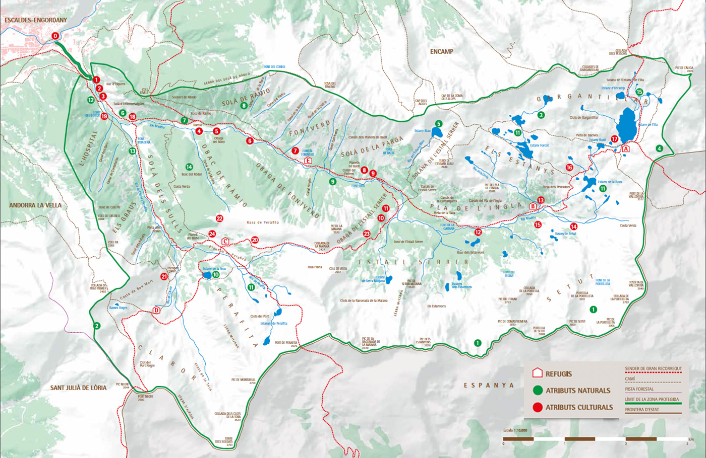
| REFUGS | CULTURAL ATTRIBUTES |
| A. Refugi de l’Illa | 0. CIAM |
| B. Refugi del Riu dels Orris | 1. Escultures d’Erik Dietman |
| C. Refugi de Perafita | 2. Borda Sabater (en ruïnes) |
| D. Refugi de Claror | 3. Borda i pont Sassanat |
| E. Refugi de Fontverd | 4. Bordes de Ràmio (7 dempeus i 4 en ruïnes) |
| 5. Infraestructures hidroelèctriques | |
| NATURAL ATTRIBUTES | 6. Borda de l’Estall |
| 1. Circs glaciars | 7. Cabanes de diferents períodes a Fontverd |
| 2. Altiplà de Calm de Claror | 8. Farga d’Andorra |
| 3. Sistema llacustre Gargantillar-els estanys | 9. Barraca de la Farga |
| 4. Difluència glaciar de Vallcivera | 10. Barraca de l’estall Serrer |
| 5. Cubeta glaciar suspesa de l’Estany Blau | 11. Pleta de l’Estall Serrer |
| 6. Cubeta d’Entremesaigües | 12. Cabana del serrat de la Barracota |
| 7. Forma en U de la vall principal | 13. Orris del riu dels Orris |
| 8. Solà de Ràmio (canals d’allaus) | 14. Orris de Setut |
| 9. Riu Madriu (interès florístic i paisatgístic) | 15. Cabana de Setut |
| 10. Estany de la Nou (interès geomorfològic i paisatgístic) | 16. Cabana dels Estanys |
| 11. Molleres (interès florístic i funcional) | 17. Infraestructures hidrolèctriques |
| 12. Bosc de ribera | 18. Bordes d’Entremesaigües (6 bordes) |
| 13. Bosc higròfil mixt | 19. Borda de cal Xic |
| 14. Bosc madur del Ròdol-Costa Verda, hàbitat d’espècies amenaçades | 20. Orris de Mateu |
| 21. Cabana de Claror | |
| 22. Orris de Perafita | |
| 23. Mines de Maiana | |
| 24. Cabana de Perafita |
| PATH | LONGITUDE | POSITIVE DROP IN ELEVATION | NEGATIVE DROP IN ELEVATION | DIFFICULTY |
| GRP del Port Negre a la Collada de Pessons | 14,86 km | 1.200 m | 1.000 m | Difícil |
| GR 11.10 de la Plana al Port de Perafita | 6,55 km | 1.350 m | 8 m | Moderada |
| GR 7 de la Plana a la collada de Pessons | 12,55 km | 1.600 m | – | Moderada |
UNDERSTANDING THE SIGNPOSTING
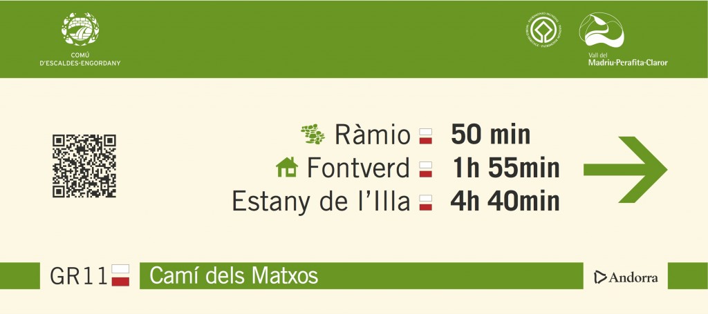
In the upper part, in green, the shield and the name of the comú, and in the outer part of the signpost their must also be the Madriu-Perafita-Claror Valley logo (in areas of joint administration of the territory, only the valley logo is displayed).
In the centre part of the signpost, in a neutral colour, three significant destinations are given: a nearby one, and intermediate one and one that is further away. These destinations can be natural or cultural values and they are accompanied, on the right, by the duration of the route and, on the left, the icon showing the kind of destination. The icons have been unified by all the official bodies so that from now on, the same ones will be used in all official supports (maps, plans, guides, etc.).
If the type of path to get to the indicated destination changes with regard to the one you are on, before the distance there is the mark associated to the type of path (GR, GRP, CI or CC).
The direction of the path is indicated by means of an arrow on the outer part of the signpost.
The lower part of the signpost is the same colour as the upper part. In the lower part you will see the kind(s) of path (GR, GRP, CI or CC), equestrian or mountain bike variants, with the associated mark. On the exterior part, there is the Andorra brand in black. Between these two pieces of information, whenever it exists, the name of the path is given.
INTERPRETATION PANELS
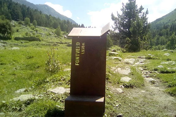 Panel at Fontverd
Apart from the orientation signals, if you walk through the valley, you will find the 13 interpretation panels that will help you interpret and read the landscape. Let’s see if you find them all!